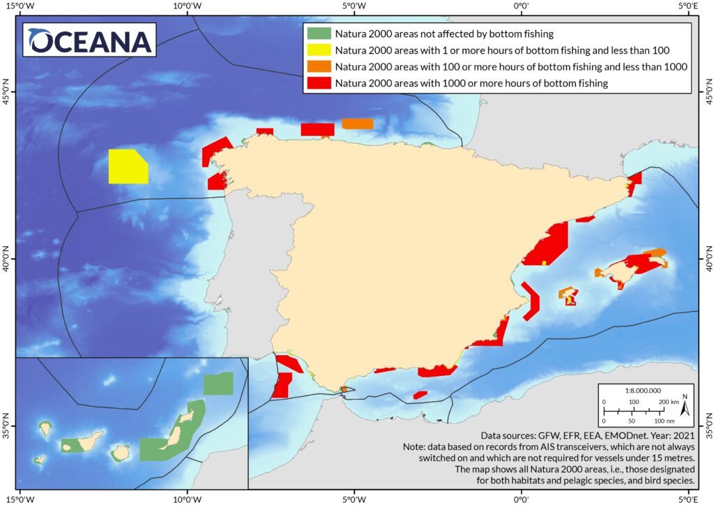
Trawling is taking its toll on Spanish marine protected areas: fishing is nine times more intensive in these areas than in the rest of the sea
Press Release Date: October 27, 2022
Location:
Contact:
Oceana Web | email: webadmin@oceana.org | tel.: 202.000.0000
A new analysis carried out by Oceana has found that the level of destructive fishing in protected areas appears to be greater than previously estimated
Having analysed apparent bottom trawling activity in Spanish marine protected areas (MPAs) in 2021, Oceana has found that this type of fishing is almost nine times (8.74) more intensive within these areas than outside. Natura 2000, the network of protected areas within the EU, which covers 8% of Spain’s marine area (88,000 km2, roughly the size of Andalusia), is estimated to have undergone 600,000 hours of apparent bottom trawling in 2021. This is equivalent to an average of 7 hours per km2 of MPA, whereas outside these areas the amount was 0.8 hours per km2. Taking only areas authorised for trawling into account, the level is still twice as high within MPAs as outside.
The fishing method of bottom trawling is one of the most damaging to the marine environment. In a previous report, “Paper parks” in Spain: bottom trawling inside marine protected areas, the marine conservation organisation warned of the high impact of bottom trawling on Spanish MPAs in 2020. The report found that areas of significant natural value, such as those designated under the LIFE+ INDEMARES project, were among the most heavily trawled. However, having analysed the 2021 records, it has become clear that that first analysis underestimated the impact of the activity, possibly due to the decline in fishing as a result of the COVID pandemic. For example, in Natura 2000 areas specifically designated for seabed protection and therefore highly vulnerable to bottom trawling, apparent trawling hours increased by an average of 42% compared to 2020.
Silvia García, senior marine scientist at Oceana: “Trawling is being carried out most intensively in the protected areas, where it should be banned. It is an activity incompatible with ocean conservation: it affects both species and habitats, and indirectly the ecosystem as a whole, and the damage is thus far-reaching and long-lasting. The government needs to address at once the impacts of fishing in protected areas; failure to do so is a breach of its obligations under environmental laws.”
Oceana has conducted numerous research projects involving the marine environment, documenting both areas worthy of conservation and areas already protected but poorly managed, and studying the impacts in areas where bottom trawling is allowed. In July 2022, the organisation undertook an expedition to the Alboran Sea, where the effects of bottom trawling on different types of seabed in Sur de Almeria–Seco de los Olivos MPA were demonstrated.
Ricardo Aguilar, expeditions director at Oceana: “We detected impacts of bottom trawling in most of the dives carried out in Sur de Almeria–Seco de los Olivos MPA, both in shallow areas and offshore. Seven years after its designation as a protected area, there is still no management plan in place and thousands of hours of apparent bottom trawling have taken place within it. This area cannot be considered a genuine marine protected area as its habitats are in a state of ongoing deterioration.“
In order to comply with its national and European commitments, Spain needs to accelerate the designation of new marine protected areas to protect 30% by 2030, and one third (10%) must be strictly protected. In addition, it must ensure appropriate management of all areas, starting from the basic premise that activities such as bottom trawling are incompatible with environmental protection. Certain protective measures, such as the designation of new areas and the development of management plans, are included in the LIFE IP INTEMARES project, but there have been worrying delays in their implementation. With regard to the designation of strictly protected areas, Spain does not have any strategy in place for reaching the minimum commitment.

Notes to the editor
- The signals of apparent fishing analysed by Oceana are signals emitted by vessels using the AIS system, an identification and location system which all EU vessels over 15 metres in length are obliged to have. Global Fishing Watch is an international organisation that collects and analyses these signals in order to monitor global fishing activity.
- The Natura 2000 network consists of the areas of greatest importance for vulnerable species such as cetaceans, turtles, and birds, and for seabed habitats such as reefs and seagrass beds, among others. These areas are essential for breeding, feeding, and sheltering marine species.
- Under Spain’s Natural Heritage and Biodiversity Act (which implements the EU’s Habitats Directive), the integrity of ecosystems in Natura 2000 areas must be preserved, and all their constituent elements must be considered in their management. Designated areas must be properly managed in order to ensure the primary objective of conserving the natural elements for which the areas were designated for protection.
- With regard to its international commitment to protect 30% by 2030, Spain currently has 8.01% of its area protected within the Natura 2000 network, which, added to the Mediterranean Cetacean Corridor, covers only 12.23% of the total protected area. In terms of the commitment to achieve at least 10% of strictly protected areas, as of today, Spain has barely 0.2%, made up exclusively of the no-take zones within marine reserves of fishing interest.
Table: Marine Natura 2000 areas designated for the protection of seabed habitats with more than 1,000 hours of bottom trawling in 2021, and increase in hours compared to 2020.
| Natura 2000 area (sea surface area) | Apparent bottom trawling 2020 [hours] | Apparent bottom trawling 2021 [hours] | Increase [hours] |
| Sistema de cañones submarinos de Avilés (3 382 km2) | 15 863 | 26 369 | 10 505 |
| Sur de Almería – Seco de los Olivos (2 834 km2) | 22 221 | 23 906 | 1 684 |
| Valles submarinos del Escarpe de Mazarrón (1 548 km2) | 11 931 | 14 884 | 2 953 |
| Sistema de cañones submarinos occidentales del Golfo de León (938 km2) | 7 903 | 13 015 | 5 112 |
| Canal de Menorca (3 356 km2) | 5 554 | 8 742 | 3 188 |
| Volcanes de fango del Golfo de Cádiz (3 178 km2) | 2 238 | 4 489 | 2 251 |
| Delta de l’Ebre (372 km2) | 2 122 | 4 005 | 1 883 |
| Costes del Garraf (265 km2) | 1 980 | 2 063 | 83 |
| Espacio marino de Alborán (109 km2) | 702 | 2 059 | 1 357 |
| Alborán (265 km2) | 531 | 1 342 | 811 |
#BanBottomTrawling #RestoreOcean

