Three out of four Spanish trawlers fished in marine protected areas in 2022
Press Release Date: November 28, 2023
Location: Madrid
Contact:
Irene Campmany | email: icampmany@oceana.org | tel.: +34 682 622 245
The information is distilled from official data from the General Secretariat for Fisheries
Trawling, one of the most destructive fishing methods, is allowed in marine protected areas despite being a threat to the ocean and the sustainability of the fishing sector
Three-quarters of the vessels that bottom trawled in Spain last year did so, at some point, in marine protected areas. This is according to official data from the General Secretariat of Fisheries to which Oceana had access. Thus, 673 vessels, out of the 887 vessels dedicated to bottom trawling in Spanish territory, fished in theoretically protected enclaves. That is, they fished with gear that was highly damaging to ecosystems in areas legally designated to protect their biodiversity. Despite being protected on paper, these areas do not have management plans that guarantee real protection from bottom trawling, and where such plans exist, they are inadequate.
Oceana’s marine scientist in Europe, Silvia García, explains that “the data shows the stark reality of marine protected areas in our country. Spain could be acting on the edge of the law by allowing trawling in these areas. It is essential that the government is coherent with its national and European conservation commitments and, to do so, it must prohibit trawling marine protected areas so that they are not just a dead letter”.
According to Oceana’s analysis of this official data extracted from Vessel Monitoring Systems (VMS), last year Spanish marine protected areas were exposed to an estimated minimum of 178,223 hours of bottom trawling, with some areas recording tens of thousands of hours of this type of fishing.1
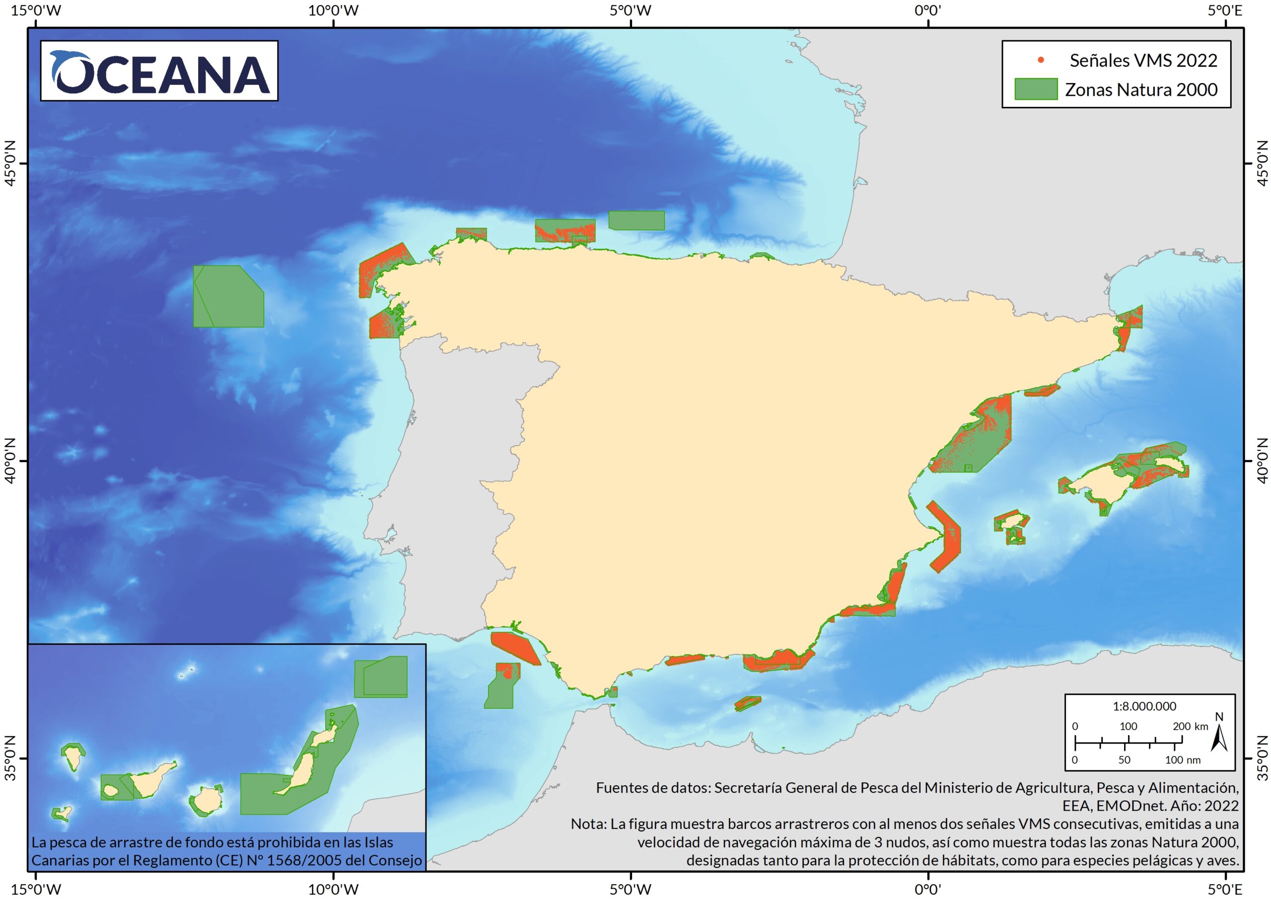
Some of the marine protected areas most affected by trawling in Spain are South of Almeria – Seco de los Olivos (Almería), Underwater valleys of the Escarpment of Mazarrón (Region of Murcia), Menorca Channel (Balearic Islands) and Avilés submarine cannon system (Asturias),1 all of which lack adequate management to protect them from the threat of trawling.
Bottom trawling consists of moving nets along the seabed, like bulldozers that sweep up everything in their path. It is one of the most aggressive fishing methods and causes severe damage to a multitude of habitats and species from the seabed to the surface, affecting vulnerable species such as sea pens, gorgonians, sponges, deep-sea sharks, and even cetaceans, turtles, and birds. In addition, this activity has devastating effects on the surrounding environment and affects the ocean’s resilience to climate change.2 In the Mediterranean, these nets can reach 220 metres in length, which is equivalent to more than four Olympic-size swimming pools.
Notes to the editor:
- This analysis has been developed from fishing activity data provided by the General Secretariat of Fisheries of the Ministry of Agriculture, Fisheries and Food, which Oceana accessed through an environmental information request. The data comes from information provided by Vessel Monitoring Systems (VMS), satellite tracking devices for fishing vessels over 12 metres in length. These terminals, also known as blue boxes, automatically send at least every two hours information about the vessel and its activity, such as date, time, registration number, position, speed, course, and gear type. The Administration uses these signals to monitor fishing activity to improve its management.
- Fishing activity has been estimated according to the speed of the vessel at the time of the VMS signal emission, considering fishing the activity at 3 knots or less, after eliminating those signals that due to their proximity to port could mean false positives or slow speed navigation. The number of vessels fishing in each marine protected area is deduced directly, as each vessel is identified with a unique code recorded next to each VMS signal. The number of fishing hours in protected areas has been estimated by calculating the time elapsed between two consecutive fishing signals that are within these areas. The estimates have been kept in conservative mode, i.e. disregarding the possible fishing times before and after the emission of the first and last signal, respectively, of each group of consecutive signals that are part of the same haul.
- The Natura 2000 network consists of the most important areas for vulnerable species such as cetaceans, turtles, and birds, and for seabed habitats such as reefs or seagrass beds, among others. They are essential areas for breeding, feeding, and sheltering marine fauna, including commercial fish species.
- The Law on Natural Heritage and Biodiversity (which transposes the EU Habitats Directive) requires the conservation of the integrity of ecosystems in Natura 2000 areas, and all the elements that make them up must be considered in their management. Designated areas must be properly managed to ensure the primary objective of conserving the natural elements for which the areas were protected.
- About the international commitment to protect 30% of its waters by 2030, Spain currently has 13% of its marine protected areas, including 8% within the Natura 2000 Network. A large part of these areas lacks adequate management measures to ensure their protection, so they are considered paper parks, as Oceana denounced in its report Paper Parks in Spain – bottom trawling in marine protected areas.3
References:
1 The following table details the Spanish marine protected areas most affected by trawling in Spain in 2022, among those specifically designated for the protection of seabed habitats:
| Marine protected area (Natura 2000) | Estimated hours of trawling | Number of vessels |
| South of Almeria – Seco de los Olivos | 31.129 | 57 |
| Underwater valleys of the Escarpment of Mazarrón | 12.718 | 42 |
| Menorca Channel | 4.811 | 17 |
| Avilés submarine cannon system | 3.935 | 34 |
| Western submarine canyon system of Gulf of Lion | 2.681 | 25 |
| Gulf of Cadiz mud volcanoes | 1.909 | 28 |
| Alborán marine area | 1.781 | 31 |
| Alborán | 958 | 28 |
| Garraf coasts | 388 | 19 |
| Eastern Strait | 186 | 5 |
2 Oceana (2022). Review of the science on the impacts of bottom trawling on the climate.
3 Oceana (2021). Parques de papel en España – arrastre de fondo en áreas marinas protegidas.