Oceana and the Spanish Institute of Oceanography develop a pioneering method in Europe to manage protected areas
The study has been carried out on Seco de los Olivos (Chella Bank), a small seamount with a height of 600 metres off the coast of Andalusia
Press Release Date: May 14, 2019
Location:
Contact:
Marta Madina | email: mmadina@oceana.org | tel.: Marta Madina
The mapping of its deep habitats could be used as a model to improve the management and conservation of this and other protected areas
In the research journal Aquatic conservation: Marine and freshwater ecosystems, the Spanish Institute of Oceanography (IEO) and Oceana have published a map of the deep habitats of Seco de los Olivos, a seamount off the coast of Almería (Andalusia). This is the first time that the methodology, which uses statistical algorithms to generate continuous maps of seabed habitats by combining visual and geological data, has been used in the Mediterranean, and it could become an international model to improve the management of marine protected areas. Seco de los Olivos is an area of great biological diversity protected in the European Natura 2000 network.
“Only 3% of marine protected areas in the world have effective management systems that take into account the ecosystem as a whole and address all the possible impacts. Most do not have management plans or focus on a few species or habitats, nor do they regulate all potential impacts. This lack of management makes them ‘paper parks’”, explained Ricardo Aguilar, Director of Research for Oceana in Europe.
Seco de los Olivos was protected in 2014, within the LIFE+ INDEMARES project.The management plan is currently being developed. It will define the uses and the activities that can be carried out in the area and will also ensure an adequate level of protection of vulnerable ecosystems.
A predictive model
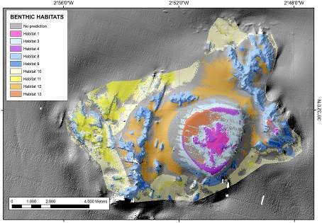
In the 3D model that has been developed, each colour represents a different biological community, and all of them harbour structuring species and great biodiversity. The distribution of all these vulnerable ecosystems occupies a major part of the seamount, which demonstrates that it is a biodiversity hotspot in the Mediterranean.
“The results obtained in Seco de los Olivos will be used to define the management plan for this protected area. The approach adopted for this work can be used as a model to follow in other marine protected areas and in particular in the Natura 2000 network,” said Ana de la Torriente, a researcher hired by the IEO and the scientist who has led the work.
The defining of the deep habitats has been made possible by a number of scientific expeditions that have sampled the seabeds of Seco de los Olivos, or Chella Bank, over a period of almost ten years. With the use of underwater robots, side-scan sonar systems, dredgers and the selective collection of samples, 13 main habitats have been identified.
The data obtained has made it possible to create a predictive model that allows the distribution of the different communities to be located on a map, which facilitates the management of the area and the application of specific conservation measures.
Vulnerable ecosystems and protected species
Seco de los Olivos is home to vulnerable ecosystems and habitats as important as coralligenous seabeds, rhodolith beds, forests of gorgonians and black corals, cold water coral reefs, bamboo corals, seapen beds, aggregations of glass sponges, etc. All these fauna communities comply with the criteria defined by the FAO for Vulnerable Marine Ecosystems (VME).
In addition, it shelters protected species such as the pilot whale (Globicephala melas), the bottlenose dolphin (Tursiops truncatus), the loggerhead turtle (Caretta caretta), the angular roughshark (Oxynotus centrina), the gulper shark (Centrophorus granulosus), tree corals (Dendrophyllya spp.), the candelabrum gorgonian (Ellisella paraplexauroides), the calyx sponge (Calyx nicaeensis), the carnivorous sponge (Lycopodina hypogea), the knobbed triton (Charonia lampas), and the slipper lobster (Scyllarus arctus), etc.
Oceana and the IEO have already worked together previously on different projects. This type of collaboration between public institutions (or research organisations) and NGOs has proven to be very effective in advancing the conservation of unique areas and vulnerable ecosystems.
Scientific article: Benthic habitat modelling and mapping as a conservation tool for marine protected areas: A seamount in the western Mediterranean
Lean more: Southern Almería – Seco de los Olivos (Chella Bank)