New study: Oceana detects apparent illegal bottom trawling in the Strait of Sicily
Press Release Date: June 9, 2021
Location:
Contact:
Oceana Web | email: webadmin@oceana.org | tel.: 202.000.0000
Evidence shows Italian vessels apparently fishing in areas where bottom trawling is forbidden
Oceana calls on the GFCM and the EU to increase transparency to ensure sustainable fisheries management in the Mediterranean
Oceana has detected two bottom trawlers apparently fishing illegally for 126 hours in one of the three areas of the Strait of Sicily where bottom trawling is forbidden. The new study released by the organisation and based on data from Global Fishing Watch also highlights that these activities have been continuous over the past few years, revealing the inaction from Italy, the European Union (EU) and the General Fisheries Commission for the Mediterranean (GFCM) on the matter. Such examples show the importance of reinforcing controls, increasing transparency, and deterrent sanctioning by GFCM Members.
“Political leaders cannot continue to turn a blind eye on illegal fishing. The Strait of Sicily is only one of many areas where secrecy in the fisheries sector affects the marine environment, hinders the activity of fishers that comply with the rules, and benefits those that ignore them. Increasing transparency and publishing information on who fishes what, where and when is essential to deliver sustainable fisheries in the Mediterranean.” says Helena Álvarez, Marine Scientist at Oceana in Europe.
The report data also sheds light on the fact that vessels with licenses to fish with multiple gears, including bottom trawls, could have been using gear types that are prohibited for use in the analysed areas.
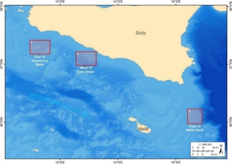
The map shows the three areas in the Strait of Sicily where bottom trawling is forbidden. They correspond to the East of Adventure Bank, the West of Gela Basin and the East of Malta Bank.
 |
|
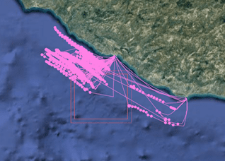
| Fishing tracks representing cumulative apparent fishing effort (number of fishing hours per square kilometre) from July 2019 to December 2020. The inner red square delimits the boundary of the area where bottom trawling is prohibited, while the outer red square delimits the 1 nautical mile buffer area surrounding the area, where bottom trawling is allowed. Each point represents apparent fishing activity as recognised by the GFW algorithm. |
To increase transparency in the fishing sector Oceana proposes that the GFCM:
- Make key data public and mandatory in the GFCM Authorised Vessel List, which should provide detailed information about all vessels that are authorised to operate in GFCM, as well as the restricted areas. The list should include all vessels actively fishing for species managed by the GFCM – including vessels under 15 metres in length.
- Improve monitoring, control and surveillance. For fishing activities within and around areas restricted to fishing, all vessels should be always detectable through position trackers. There should be stricter reporting requirements for vessels fishing in restricted areas, such as more frequent transmission of position data.
- Adopt effective sanctions for non-compliant cases. When non-authorised vessels operate inside restricted areas, GFCM members should report it to the GFCM and impose sanctions, including listing the non-compliant vessels on the GFCM IUU vessel list.